Showing posts with label Northwest Territory. Show all posts

Saturday, March 8, 2025

Land Reform American Style Screwing Speculators and Populating the Breadbasket


This map shows Land Districts and Offices in charge of selling Western land--a primary income source for the Federal government which helped keep taxes and tariffs low.  Some land agents, however, were corrupt and scandals common.  Individual speculators and organized stock companies borrowed money to buy vast tracts of land in the hopes of selling at inflated prices to settlers.  But most settlers could not afford the asking prices, the speculators and companies often could not pay their loans.  The result was financial failure and instability on one hand and a huge pent-up demand for cheaper land.  The Land Act of 1820 was meant to address both problems. 

The Land Act of 1820 is a nearly forgotten piece of legislation passed by Congress which opened the Old Northwest Territory and Missouri to an avalanche of new settlement. It was a byproduct of the Missouri Compromise. Population growth in the West had been stymied by the almost constant bloody Indian warfare in the region from the end of the Revolution through the War of 1812 and by the high land prices and large minimum parcels required by the Land Ordinance of 1785
 
When a financial panic swept the nation in 1819 it became impossible for most would-be settlers to borrow the money needed to legally buy the land. To escape high land prices mostly Scotch-Irish pioneers often pushed out ahead of land surveyors and squatted on land. When the government caught up with them they argued that their improvements on the land should be subtracted from the cost. They were often displaced and pushed further west. 
 
A deed to land in Indiana sold to James Benton McMurry in 1831 under the terms of the Land Act of 1820.  Note the document is attested to and initialed by President Andrew Jackson (or by a designee in the Executive Mansion under his authority) which was required by law for all sale of Federal land.  An example of the administrative minutia early Presidents were saddled with.
 
To make settlement more affordable and thus to reduce squatting, the new act reduced the minimum tract from 160 to 80 acres, a manageable family farm in the generally rich soil of the West
 
Buying land exclusively on credit—as was common among land speculators—was eliminated. The price was reduced from $1.65 (set in 1804) to $1.25 per acre with a relatively affordable $100 down payment. The very poorest, who probably could not even afford the necessary tools and equipment necessary to bring the land into production, were eliminated, but the cost was low enough to be manageable by many. 
 
Although speculators could still form land companies and buy large blocks of tracts, the recurring financial panics over the next few years drove many to bankruptcy while owner-operated farms could endure hard times on a subsistence basis. In the end most of the farmland in the region sold at, or not much above the Federal price. 
 
New Salem in Illinois was first settled in 1828 and was typical of the communities that sprang up across the West with liberalized land sale policies.  Even there not everyone could afford land.  Newcomer Abraham Lincoln from Indiana had to hire out as a wood cutter, river boatman, and store clerk.

The success of the policy was astounding. Illinois, for instance, had a population of about 55,000 in 1820. Over the next 40 years the population doubled every ten years to almost 900,000 in 1860. 
 
Land sales were vigorous enough that even at the reduced price enough revenue was generated to operate the nearly skeletal Federal government. In fact, they provided enough income that they were largely responsible for the Federal Debt to be completely paid off and retired—if only briefly—during the administration of Andrew Jackson
 
Such a rapid explosion for population also had a dramatic effect on government as new Congressional seats were allotted with every new census giving the West considerable regional clout. By the eve of the Civil War the states covered by the act were no longer on the frontier. They were well settled, prosperous, and with the advantages of easy access to markets via the great river system and the new railroads, had become the breadbasket to the nation.

Friday, May 2, 2014

The Corporation That Ruled Half a Continent

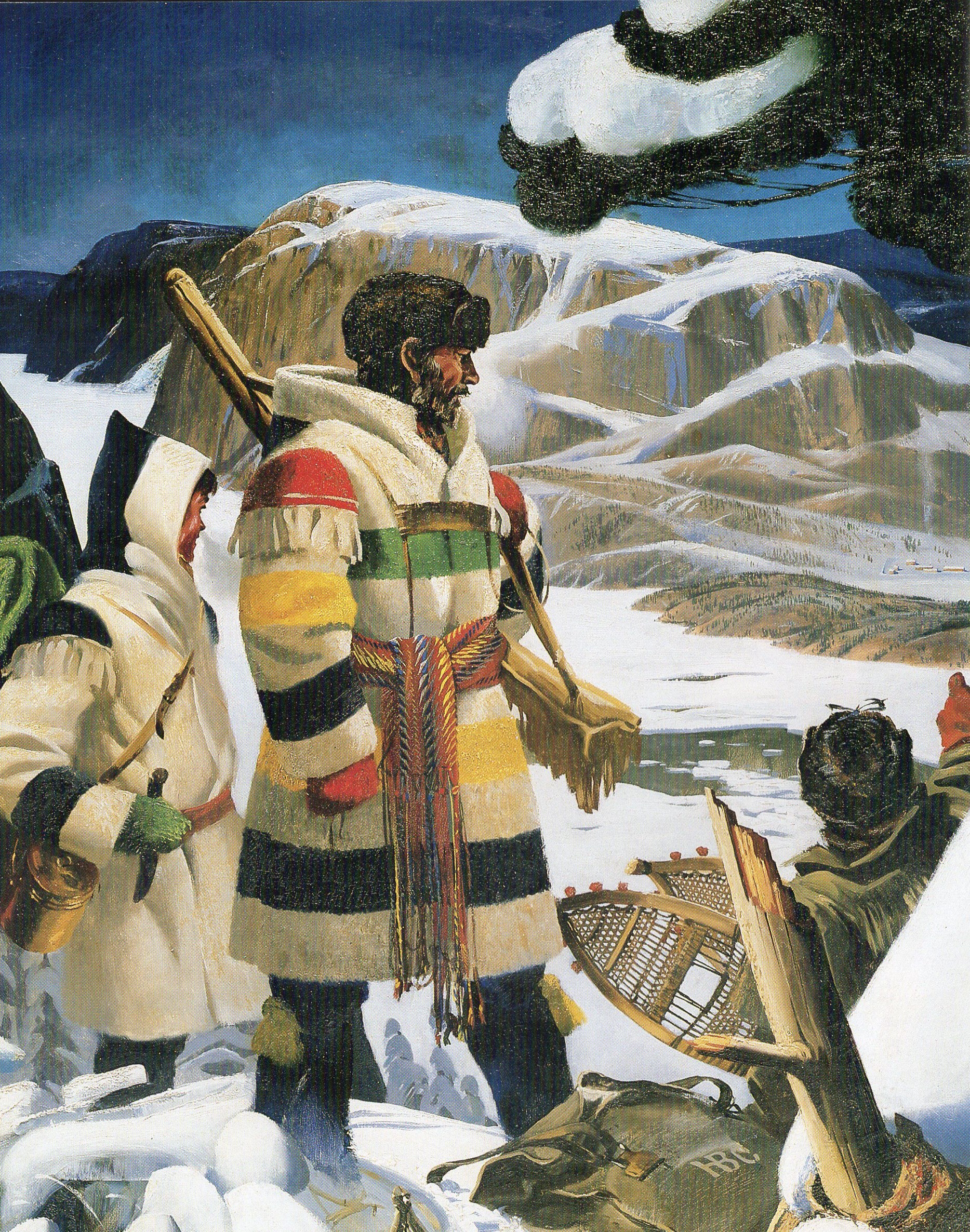
Trapper wearing a coat made from a traditional Hudson's Bay Point Blanket.


On May 2, 1670 King Charles II of England granted a Royal Charter to The Governor and Company of Adventurers of England trading into Hudson’s Bay.  Not only was it one of the first corporations, it was soon one of the richest and most powerful in the world.  Within decades it would control a fur trading empire including the vast Hudson’s Bay drainage and including far flung outpost as far away as the Pacific and extending deep into what would become U.S territory trading exclusively with hundreds of indigenous tribes.  It owned outright fully 15% of all North American land excluding Spanish possessions and virtually controlled almost all of what is modern Canada excluding the Maritimes, Quebec, the southern portions of Ontario.  And this dominance extended well into the 19th Century.

All of that wealth and power would likely have remained in French hands had it not been for the extremely bad judgment of a colonial official.  

Pierre-Esprit Radisson and Médard des Groseilliers a/k/a Médard de Chouart, Sieur des Groseilliers Two traders working from established French fur trading posts near the Great Lakes got wind of Cree stories of fabulous new fur county north of and beyond Lake Superior including rumors of a frozen sea to the north.  Believing that access to the sea from the north would via a new trading post on Hudson Bay would save the cost of overland transportation to the St. Lawrence route to the Atlantic, they asked for permission to establish one.  Not only were they turned down, they were absolutely forbidden from trading north for fear that lucrative monopolies on the St. Lawrence would be disrupted.  The two pressed ahead anyway believing that arriving in Montreal laden with valuable furs would open eyes.  And indeed they returned from a1659-60 expedition to the upper regions with just such a fabulous hall.

Instead of being hailed as heroes, however, the pair was arrested for trading without a license and their furs confiscated—to be sold a tidy profit on no investment by the very official who commandeered them.  Infuriated, upon release the pair made it to the main port of French rivals in North America—Boston.  The flinty-eyed merchants of Boston may have detested the Papist swine and feared French power, but they knew an opportunity when they saw one.  Boston investors helped the Frenchmen outfit a ship to sail into Hudson’s Bay, which the English had shaky claims upon based on the final voyage of Henry Hudson back in 1610-11.  The 1663 voyage, however, failed when the Frenchmen’s ship became locked in sea-ice in the bay.

Still, the long term prospects for the venture looked encouraging enough that one Boston backer sent the two to London to seek new financing.  The hapless pair arrived in England in 1665, at the height of the Great Plague when business of all sorts was at a virtual standstill.  They languished for years in fruitless search of a benefactor.  Finally they encountered Prince Rupert of The Rhine, a cousin and favorite of Charles II.  He agreed to be a sponsor and investor and introduced the pair to the King, who likewise was intrigued and invested for his private purse.  That attracted still more capital, secured by the valuable Royal Charter.

That outfitted two ships, The Nonsuch was commanded by Captain Zachariah Gillam, who was accompanied by Groseilliers, and The Eaglet was commanded by Captain William Stannard and accompanied by Radisson which sailed in June 1668.  While The Eaglet was forced to turn back after running into heavy seas off Ireland and sustaining heavy damage, The Nonsuch completed the dangerous sail to the southern rim of Hudson’s Bay.  A trading post, Charles Fort (later Rupert House), was established at the mouth of the river named for the expedition patron, Prince Rupert, on James Bay.  By next summer the ship set sail with a full load of furs traded from the natives.  In London the cargo was sold for £1,233, an enormous sum and more than enough to pay for the expedition and turn a tidy profit.

On the basis of those kinds of results, Charles II issued his Royal Charter which granted the company a monopoly on all trade from Rupert’s Land--the region drained by all rivers and streams flowing into Hudson Bay.  A Royal Governor was appointed and English merchant adventurers became factors and agent’s overseeing a growing number of fort/trading posts-- Rupert House, Moose Factory (1673, south) and Fort Albany, Ontario (1679, west) on James Bay and three  posts were established on the western shore of Hudson Bay proper, Fort Severn (1689), York Factory (1684) and Fort Churchill (1717).  York Factory became the most important and eventually headquarters for the Company.

The Factor employed mainly French and eventually French/native mixed breeds to go into the wilderness to trade with remote tribes, and do some trapping on their own and to encourage the tribes to visit the Factories to trade and barter.  

This system quickly cut into profits by the French, who organized raids on Hudson Bay posts.  During King William’s War 1688-97 several posts changed hand multiple times.  And during Queen Anne’s War 1702-17 the company lost all of its outposts except Fort Albany but all were returned to the Company under the terms of the Treaty of Utrecht.  The wars disrupted Company operations and no dividends were paid to stock holders for twenty years.

With relative peace restored—further Anglo-French conflicts would be less disruptive to the fur trade, the Company was finally able to become the economic engine of the dawning Empire rivaling even the East India Company, in which the Hudson Bay Company became heavily invested. 

By the early 18th Century trade values were regularized around a standard trading unit known as the Made Beaver (MB)—a prime pelt ready for processing.  The value of other furs and hides were calculated in relation to the MB.  Trade goods such as knives, kettles, beads, needles, and the Hudson’s Bay point blankets were fixed to the MB, eliminating much of the haggling of the French trading system.  By the mid 1700’s point blankets made up 80% of the value of trading goods.  These heavy woven wool blankets had heavy stripes.  In 1774, as tensions rose with the English Colonies on the Atlantic seaboard, the Company began establishing inland trading posts, the first being Cumberland House in what is now Saskatchewan.

The American Revolution quickly became part of another Anglo/French world war.  French squadron under Jean-François de Galaup, comte de Lapérouse captured and demolished York Factory and Prince of Wales Fort, a strong, modern stone and masonry star fort at the mouth of the Churchill River.

That disruption, however cost the Company fewer headaches than the creation of a new rival, North West Company (NWC) was founded in Montreal in 1779 and the first domestic joint stock corporation in North America.  Soon the NWC was operating its own string of trading posts and once again diverting trade from the Northerly route through the Bay to access to world markets through the St. Lawrence.  Fierce competition between the companies forced up prices for furs and cut deeply into profits.  In the field, competition was often violent with traders and native allies raiding each other’s camps and sometimes fighting pitched battles.

The British Government stepped in in 1824 and forcibly folded the NWC into the Hudson Bay Company.  Redundant and competitive posts were closed or consolidated.  The company was also extended trading rights to the vast new Northwest Territories and with the creation of the Columbia Department to the Pacific Ocean in the west.

Through the 1830’s John Jacob Astor’s American Fur Company based in Astoria dominated the rich Pacific coast fur trade.  But with the establishment of Fort Vancouver on the Columbia River the company gained the upper hand.  While it sent expeditions deep into Northern California—dangerously claimed by both the Spanish and Russians, the Company did everything in its power to discourage American encroachment by both overland fur traders and land hungry immigrants. 

Under terms of an 1818 agreement, no formal boundary had yet been established between US and British territory but Oregon was supposed to be jointly administered by the two nations with trading rights to both.  At best it was a tense relationship.  As immigrants began pushing west, the Company established Ft. Boise astride one likely route and bought the American trading post at Fort Hall.  Traders at both posts did everything they could to keep immigrants from coming.  But in 1843 Marcus Whitman led the first successful immigrant train along the Oregon Trail to the Willamette Valley which was followed by a flood of immigrants and foretold the doom of the Oregon fur trade.  When the boundary was established at the 49th Parallel after much bluster and sabre rattling by the Americans, the company abandoned Oregon.

Through these years the Company was getting richer, and also more complex.  MBs might due as a trading standard in the wilderness, but for increasing operations in civilization, cash was required.  For more than thirty years the Company issued its own bank notes, denominated in Pound Sterling and printed in London.

The company’s insistence on enforcing its trading monopolies set the stage for one of the great crisis of Canadian history—the rebellion of the mixed race  Métis that had its roots in the trial of  Guillaume Sayer for illegal trading.  A large group of Métis led by Louis Riel, Sr. staged a noisy, armed demonstration outside the Company court house.  Sayer was convicted, but not fined de facto ending the monopoly.  The Red River Métis would form their own company and trade across the border into the United States.  Under the leadership of Louis Riel, son of the earlier leader, there would be two rebellions, the first resulting in the establishment of Manitoba, and the final North-West Rebellion of 1885 that was crushed by the new Dominion of Canada.

Meanwhile the British North American Exploring Expedition or Palliser Expedition explored and surveyed the open prairies and wilderness of western Canada from 1857 to 1860—all here to fore the domain of the Hudson Bay Company.  The Expedition was charged with finding a possible rail route to the Pacific.  But it also issued a report that while discouraging immediate settlement showed that much of the prairie was likely prime agricultural land.  The Company had always maintained that the west was entirely unsuitable to settlement to protect its fur trade.

When the consortium of the International Financial Society became the majority stockholder in 1863, it began looking for new infusions of cash just as Canada was emerging as a quasi-independent Canadian Confederation.  In 1869 the company approved the return of Rupert’s Land to Britain which in turn gave it to Canada and loaned the new country the £300,000 required to compensate for its losses. The Deed of Surrender came into force the following year. The Northwest Territories was brought under Canadian jurisdiction under the terms of the Rupert’s Land Act 1868, by the Parliament of the United Kingdom. The Deed enabled the admission of the fifth province, Manitoba to the Confederation on 15 July 1870. 

Although fur trading remained a cornerstone of the business, the influx of settlers into the Prairie Provinces and British Columbia transformed trading posts into mercantile stores, selling directly to settlers for cash.  Over vast areas of rural Canada Hudson Bay Company operated virtually the only local stores.  The first such shop was established as early as 1857 at Fort Langley on the Frazier River.  Other stores soon followed.

In 1913 Hudson Bay entered the Department Store business with a grand new store in Calgary Alberta, quickly followed by more big stores in Edmonton, Vancouver, Victoria, Saskatoon, and Winnipeg.  After World War I the company expanded with store in Ontario and Quebec.

As retail sales became an ever bigger part of the business, the Hudson Bay Company began retreating from the fur trade and diversifying into real estate holdings and Petroleum companies.  Hudson's Bay Oil and Gas Company (HBOG) became a major Canadian oil producer in combination with other producers and consolidation and began exporting oil to US refineries by pipeline to Billings, Montana.  After a severe dip in international oil prices, the Company sold its controlling interest in HBOG and exited the energy business.

Shortly after, it ended its participation in the fur trade, which had become a public relations nightmare for the company over the annual baby seal hunts in the arctic.  It sold all of its remote Northern trading posts and fur business in 1987,

By that time the Hudson Bay Company had ceased to be a British corporation under Royal Charter.  Due to heavy taxation in Britain, the company dissolved it Royal Charter on its 300th anniversary in 1970, moved its headquarters to Winnipeg, and became a Canadian company. 

The company aggressively moved into greater and greater retail operations, buying up one after another established chains including Morgan’s allowing it to expand into Montreal, Toronto, Hamilton, and Ottawa.  It re-branded all store as The Bay.  More chains were acquired, including the Zellers discount store, Simpson’s.  Through a succession of majority owners, most notably billion are Kenneth Thompson and his family from 1970-97, the Hudson Bay Company continued to gobble up competitors large and small including Tower Department Stores, Woodward’s, and K-Mart Canada.

The company is now owned by NRDC Equity Partners, an American equity trading corporation which already controlled Lord & Taylor luxury department stores.  It transferred management of Lord & Taylor to the Hudson Bay Company.  In 2013 it also purchased another flagship luxury chain, Sax Fifth Avenue.  

Today the company operates hundreds of store in the United States and Canada and is once again diversifying.  But it still sells those trade blankets at its Hudson Bay Stores—and gets a pretty penny for them, too.

Wednesday, December 14, 2011

The Grand and Glorious Toledo Strip War


The annals of American history are rife with glory.  But who can match those stirring days of 1835-36 when the brave lads of the State of Ohio stared down the stalwart sons of Michigan Territory and won the prize—the Toledo Strip.  Or did they really win, after all?

Militias on both sides were mobilized and facing each other across the mighty Maumee River on that cold day, December 14, 1836 when a Michigan conclave known to history as the Frost-Bitten Convention, meeting under pressure from Congress and President Andrew Jackson agreed to give up its claim on the port of Toledo on Lake Erie and a narrow strip of 468 square miles stretching to the Indiana border.

In exchange for losing the lucrative port and fertile land, Michigan would be admitted to the union and was awarded a virtual waste/wilderness of Native American land on 3/4s of the Upper Peninsula between the shores of Lakes Michigan and Superior—land that was previously in Wisconsin Territory. 

Michiganders were sure that they got a raw deal.  Voters had previously overwhelmingly rejected essentially the same terms offered by Congress in exchange for ceding its claims on the strip to Ohio.  But the Territory was near bankruptcy and without the author to levy and raise taxes and sell certain public lands which came with statehood, government would be unable to function.  Thus the desperate Frost-Bitten Convention.

The dispute had its roots going back to the Northwest Ordinance of 1789 which organized the territories west of Pennsylvania and north of the Ohio River.  “Not less than three and not more than five” future states were to be carved from the vast land.  The north-south boundary for three future states—Ohio, Michigan, and Indiana—was supposed to be a continuous “…east and west line drawn through the southerly bend or extreme of Lake Michigan.”

Unfortunately, no one knew exactly where the “southerly bend of Lake Michigan” was.  The best available map of the day guessed that it was at about the same latitude as Fort Detroit.  That map was seriously wrong.

In 1802 Ohio held a constitutional convention to prepare for applying for statehood.  The draft constitution assumed that the so called “Mitchell Map”, the best available, was correct and laid claim to boundary north of the Maumee River, which would give the new state all of ports and potential ports on Lake Erie west of Pennsylvania.  In the course of the Convention, delegates heard reports from a trapper who had worked the portage between Lake Michigan and the Illinois River that the southern tip of Lake Michigan extended much further south than they had believed.

The Convention submitted the Constitution to Congress that continued to assume a northerly boundary but which maintained that in the case that was proven wrong, a departure from the main line should be made angling south to include the mouth of Maumee on Erie, thus guaranteeing Ohio a port.

Congress at first accepted the Constitution with the rider of understanding intact.  But then a committee dominated determined that the exact line, “had yet to be determined.” And then left the issue dangling.  But Ohio assumed a boundary well south of today/s line.

Three years later Michigan submitted its first attempt to statehood recommendation.  Its documents assumed a southern line that would in include the Port of Miami, later known as Toledo.  And Congress adopted that resolution, thus setting up two conflicting definitions of the boundaries.

Ohio residents eager to fortify their claims, continually begged Congress to clear up the contradiction.  Finally, in 1812, it agreed to have the line formally surveyed.  But the War of 1812 and subsequent conflicts with native tribes on the Northwest frontier delayed the dispatch of surveyors until after the admission of Indiana to the Union in 1816.  Then the U.S. Surveyor General, Edward Tiffin, a former Ohio governor, sent teams into the field who Michiganders deeply suspected.

The Northwest Ordinance might as well have been named the “Land Surveyor Full Employment Act of 1787.”  Just about anyone who owned a surveyor a set of surveyor’s chain links and a sextant or could steal them got a chance at federal employment as a vast area had to be laid out.  Needless to say some were more adept than others.  And some could be, ahem, bribed, by local interests and land speculators.

Surveyor William Harris and his crew submitted a northerly line based on the lines of the Ohio Constitution.  Michigan Territorial Governor Lewis Cass, a powerful Democrat, complained loudly then commissioned his own survey which followed the directions of the Northwest Ordinance.   The three to five mile wide strip between the two lines became known as the Toledo Strip.

Although Ohio never ceded its claims, Michigan began a de-facto occupation of the disputed land.

Meanwhile the Erie Canal was completed linking New York City on the Hudson River to Lake Erie at Buffalo.  That made the potential port at the western tip of the lake, Toledo, the gateway to western expansion.  Ohio suddenly became very interested in renewing it claims.

When Michigan reached a population of 10,000 and was thus eligible for admission to the Union as a state in 1833, it found its ambitions crushed by Ohio supporters who demanded the implementation of the northern line.

In February, 1835 Ohio moved to form counties out of the disputed strip.  Michigan’s Territorial Governor, 23 year old Stevens T. Mason, and the Territorial legislature responded by making it a felony for any citizen to recognize the authority of the new Ohio counties or respect their ordinances.  Mason, for obvious reasons, was known by the nick names The Boy Governor, Young Hotspur, and The Stippling depending on one’s opinion of him.

Mason appointed an active duty Regular Army officer, War of 1812 hero General Joseph Brown, as head of the Michigan Militia.  Ohio Governor Robert Lucas mobilized his own militia under his direct command with the assistance of General John Bell.

In March of 1836 Lucas and Bell marched 600 troops to Perrysburg only ten miles from Toledo.  Mason countered by sending 1,000 men—a huge portion of his adult male population—to occupy Toledo itself and fortify the Maumee line.  The Toledo Strip War was officially begun.

President Jackson and Congress were desperate to find a solution, but practical politics got in the way, Michigan’s biggest congressional supporter, former President John Quincy Adams, then sitting as a Member of Congress from Massachusetts, reported mournfully that, “Never in the course of my life have I known a controversy of which all the right so clearly on one side and all the power so overwhelmingly on the other.”

When President Jackson asked Attorney General Benjamin Butler for an official opinion on the dispute, he got an answer that he did not like—that until Congress dictated otherwise, the land rightfully belonged to Michigan.  The problem for Jackson was that Ohio had grown into a political powerhouse with 15 Representatives in Congress in addition to its Senators.  That translated into 17 Electoral College votes in the upcoming Presidential Election.  Despite the fact that Ohio leaned Whig, Jackson hoped that if he helped settle the matter in the state’s favor, he might win those electoral votes. 

So the pressure was on Michigan to capitulate.  But Michigan was not yet ready. Jackson sent emissaries to the scene to “arbitrate” the dispute.   Believing the mater settled in his favor Gov. Lucas de-mobilized his troops and moved to have local elections in the disputed area under Ohio law.

Mason was defiant.  He kept his forces in the field, announced his intentions of enforcing Michigan’s Pains and Penalties acts on anyone participating in the election.  On April 8 a Michigan sheriff arrested Ohio partisan Major Benjamin Stickney and another family member under the act.  His forces tried to prevent polling places from opening where ever they were able.

But the Michiganders were unable to stop the election.  Governor Lucas decided to celebrate by ordering surveyors to prominently mark the border as recognized by Ohio.  On April 26 a large party of surveyors at Phillips Corners was confronted, “as they observed the Sabbath” by 50 Michigan Militia.  Ordered to retreat, the majority got away, but seven were captured by Michigan after either being fired upon, as Ohio tells the story, or after hearing the Militia fire their guns in the air to celebrate the victory, the Michigan version.  This bloodless “battle” was the only organized military action of the war.

In response to the action, the Ohio Legislature designated Toledo the county seat of a new Lucas County, named for the Governor, and established a court specifically to hear cases of “abduction and unlawful imprisonment”  against Michigan officers and politicians.   

Mason and his legislators replied by appropriating an astounding $315,000 for its Militia—a disastrous move that soon broke the government.  They also drafted a new Constitution to be sent to Congress.

All summer both sides mobilized their forces and retched up their rhetoric.  Michigan Sheriffs continued to try and arrest Ohioans.  Ohio authorities filed a blizzard of lawsuits and made their own arrests.  When a Michigan posse arrived in Toledo to arrest Major Stickney and his family again, a scuffle broke out and one of Stickney’s adult sons stabbed a deputy with a pen knife.  The non-lethal wound was the only known bloodshed, apart from some bloodied noses in fist fights, of the entire war.

Mason asked President Jackson to intervene or to refer the case to the Supreme Court.  Jackson declined, and on the advice of an Ohio Congressman removed Mason as Territorial Governor and replaced him with a more tractable politician, John Horner, known, for obvious reasons as Little Jack.  Before his replacement could take over, Mason ordered 1000 militia men into Toledo to prevent the first session of Ohio’s new court.

Ohio authorities opened a brief, late night session to symbolically assert authority, and then retreated before the Michigan forces arrived.

Michiganders hated their new Governor and harassed him at every turn.  In the November elections, they approved the Constitution drafted over the summer and re-elected Mason by a landslide.

Congress, however, refused to recognize the Constitution and would not seat either the would-be states sole elected Representative or either Senator.

The stand-off on the ground continued into 1836, with Michigan practically burning money.  The much more populous Ohio could easily afford their little war.

In August, President Jackson signed legislation admitting Michigan, but only if they gave up claims on the Toledo Strip.  Voters rejected that condition overwhelmingly in November.

But over the winter, reality finally sat in.  Mason was forced to call his Frost-bitten Convention and accept an only slightly sweetened offer.

Ohio was jubilant, their war aims secured.  But Michigan may have had the last laugh.  The “worthless” Upper Peninsula turned into an economic powerhouse when copper was discovered.  Within decades it was one of the world’s largest producers.  Its vast forests fed the needs of a nation exploding in population and expanding its boundaries.

Toledo thrived for a while as a port.  But its significance was soon challenged by the increasing network of railroads.  In the late 19th and early 20th Centuries, it became a major manufacturing center.  But its aging factories were hit hard by the oil crisis recession of the ‘70s.  A quintessential Rust Belt city, its fortunes have continued to decline.  Today it is a shadow of itself having lost more than half of its population, much of its land empty after old factories were torn down to become poisonous brown fields.  Many Ohioans would just as soon give the place back to Michigan.  But Michigan with plenty of problems of its own doesn’t want it.

Today the great Toledo Strip War lives on mostly in the intense rivalry between college and professional sports teams—especially the University of Michigan vs. Ohio State in the Big Ten.