 | ||
| This 1887 map, two years before the annexation votes shows Chicago and its surrounding townships including Lakewood, Jefferson, Cicero, Lake, and Hyde Park that were soon joined to the city. |
June 29, 1889 was indeed the day Chicago blew up. No, you didn’t miss reading about some disaster to rival the Great Fire
of 1871. That was the day the city blew up from a compact two square miles or so stretching
from the Lake Front west to Kedzie Avenue and north from what is
now Pershing Road to Fullerton Avenue to the form the largest city in the United States
by area and second largest in population.
On that day four large Townships
and a portion of a fifth one,
voted to be annexed into the City. It was the largest single day of growth ever, but would not be the last as the Windy City continued its phenomenal growth by gobbling up neighbors well into the mid-20th
Century.
If you are a 21st Century Chicagoan your required-by-law wise guy cynicism
would probably lead you to suspect
the City muscled its way over its
neighbors or that the separate elections
held in each township were fraudulent.
But apparently not. The city offered superior municipal services—especially
clean Lake Michigan water
and—thanks to the lessons of the Great
Fire—a modern, well equipped Fire Department.
And that was nothing to be sneezed at
in the townships where most of the housing was built of wood. In
addition, city taxes on residential
property were, in most cases, actually lower
than those assessed by the townships
due to the large base of commercial
and industrial property.
And when it came to corruption and cronyism some of the townships
had even worse reputations than the city.
 |
| There was celebrating at Chicago City Hall after the vote which made the city the second metropolis of the nation by population and by far the largest by land area. |
The City of Chicago had been incorporated in
1837. In 1850 under a new Illinois Constitution the rest of Cook
County was divided into Townships
for administrative services.
These townships could petition to be
organized with certain municipal powers with the signatures of as few as 300 voters. The legislature could, and did, sometimes enact special legislation granting authority to specific
townships.
As the rural
areas surrounding the city gained in
population, one by one they became organized
with functioning units of government.
Here is a short
survey of the Townships that joined the city in 1889 from north to south.
Lake View was a largely rural area directly north of the city. It
was settled largely by farmers from Germany,
Sweden, and Luxembourg in the 1840’s and ‘50s. Their largest cash crop, by the way, was celery
of all things. In 1854 a resort
hotel—Lakeview House—was built near current Lake Shore Drive and
Byron Streets giving its name to the area. The area along the lakefront prospered as a resort and
eventually as a suburban haven for
the upper middle class. The coming of the railroad
increased rapid development of more modest and working class subdivisions to
the west.
 |
| The Lake View Town Hall, later site of the Chicago Police Department Town Hall District Station. |
In 1857, the area now bounded by Fullerton, Western, Devon, and the Lake was organized
into Lake View Township. A town hall was built in 1872 at Halsted
and Addison, the location of which was commemorated by the old Chicago Police Department Town Hall
District Station at the same location. The Township exploded in population growing from 2,000 in 1870 to 45,000 in 1887
when much of the Township was incorporated
as the City of Lake View. Despite this development voters passed
the annexation referendum just two years later in what was one of the more hotly contested elections.
Jefferson Township to the west of Lake View was still more rural as the railroads were slower
in coming. It was bounded by Devon Avenue on the north, Harlem Avenue
on the west, Western Avenue to the east, and North Avenue to the
south. Small settlements sprang up
along the old Indian trails and military roads known as the
North West Plank Road (later Milwaukee Avenue) and the Lower Road
(Elston Avenue) which allowed crops and produce to be laboriously hauled to market in Chicago
by wagon. Later the Chicago,
St. Paul & Fond du Lac Railroad which became the Chicago & Northwest
Railroad spurred development of several villages. The Village of
Jefferson dates to 1855 and Irving Park to 1867. Jefferson
Township lost its northwest corner
to newly created Portage Park Township in 1872. The Township
covered almost all of what is now called the Northwest Side.
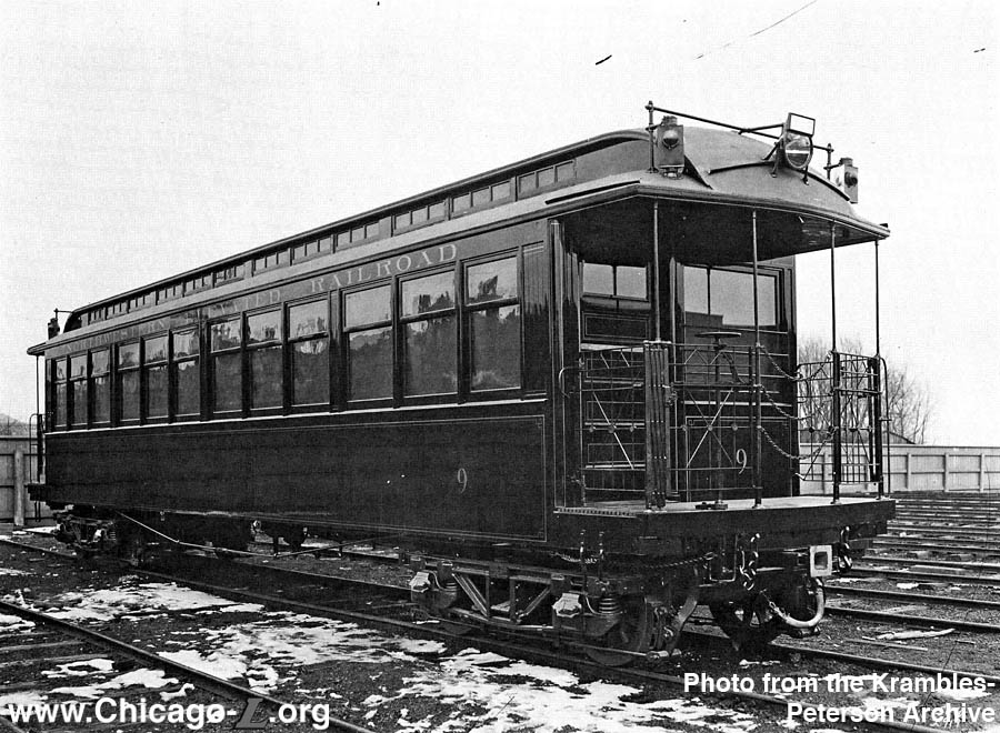 |
| Street cars, inter-urbans, commuter rail lines, and services like those provided this Northwest Elevated Railway car, were the fuel that led to rapid development of new subdivisions in all of the Townships. |
Cicero Township, directly west of the City of Chicago, was organized in 1857.
It experienced a population explosion following the Civil War, as usual
spurred by convenient rail access to the city. In 1867 the state
legislature incorporated the Town of Cicero as a municipality with a special charter, which was revised in
1869. Township and municipal functions
were discharged by a single board of
elected officials. In that reorganization
Chicago annexed almost half of the Township which became known as West
Town. The City was able to lure
residents of a strip comprising
most of the eastern quarter of the
remaining Township running from North
Avenue south to Pershing to vote to de-annex from that
body in join the city in the 1889 referendum, due in no small part to dissatisfaction with corruption in the Town
government—corruption that became an unshakable
tradition.
 |
| Sprawling Union Stock Yards and the meat packing plants it serviced were the economic engines for the explosive population growth in Lake and Hyde Park Townships. |
Lake Township, which despite its name was nowhere
near the lake. Bounded on the east by State Street it
stretched west to Crawford Avenue and ran from 37th Street to 87th
Street. Settlement in the area was boosted by the construction of the
Illinois and Michigan Canal that linked the head of navigation at
La Salle on the Illinois River—and from there the Mississippi—and
the Chicago River and Lake Michigan which was completed in 1844. Irish
canal diggers established the
settlement of Hardscrabble, later known as Bridgeport at the conjunction of the Canal and the South
Branch of the Chicago River. The Canal encouraged the establishment
of and use of the truck farms in region to supply the Chicago market with fresh produce. The opening of the
Union Stock Yards in 1865 led to overnight
growth. More than 10,000 residents poured into the area in the first
ten years, most of them employed by
the stock yards or meat packers and crammed
into ramshackle housing. Those workers overwhelmingly supported joining the city.
Hyde Park Township was at the time regarded as
the prestigious crown jewel of the
1889 annexations. It was bounded by 39th
Street, today’s Pershing Road,
on the north and 138th Street and the Calumet River on the south
and by State Street on the west and
Lake Michigan and the Indiana state line on the east. Shortly
after the 1850 creation of the township, Paul Cornell, acting on an insider’s tip from Senator Stephen
Douglas that the Illinois Central Railway was coming, personally
paid for a topographical survey of the township two years later.
In 1853 he bought 300 acres between 51st and 55th Streets and set
about developing the first Chicago railroad
suburb.
Douglas also invested
speculatively in the area and—surprise,
surprise—did quite well.
Cornell named the village he was creating Hyde Park after the affluent New
York City suburb hoping to
attract wealthy citizens willing to commute to work in the city by train.
It worked. Hyde Park was soon a very toney and affluent community.
Because it was completely disconnected from Chicago’s grid system except for
State Street, the village’s north-south streets never fit will,
creating isolation and transportation nightmares familiar to city
residents to this day. The Township was re-organized with expanded municipal
authority in 1861. Most of the land north of the village to the city
limits remained rural until the completion of the Stock Yards spurred
spill-over development from Lake Township. Population swelled from
15,750 in 1889 to 85,000, much of that from the development of George
Pullman’s model town and railway car construction shops.
Unlike other Townships, Hyde Park had invested in a built its own water
system using Lake Michigan. Despite this and the fervent desire
of the wealthy folks in the village of Hyde Park to remain independent, working
class voters overwhelmingly approved annexation in 1889.
 |
| George Pullman's model town and shops were a plum in the annexation of Hyde Park Township. |
The townships still
exist but have no current
governmental structure or functions
except for being used by the Cook County Assessor’s office for taxation valuation
and record keeping purposes.
There you have it, in one great gobble the City of
Chicago expanded nearly to its current boarders swallowing almost all of the
current North, Northwest, West, South, and East sides. I wonder if it
burped.